CYBERPORT PHASE V CONCEPT PROPOSAL


EXPLORATORY GOALS
01: Community Asset Development
Develop a design strategy that makes the Waterfront Park an essential community asset in the southern district and a destination in the region.
02: Redefine Public
Consider methods for cultivating ‘public’ civitas via the development of ecological bio-diverse reverse reclamation waterfront and by enriching and diversifying the modalities and textures of recreational use across the park/waterfront.
03: Recast Research Hub
Mixing technology, economics and scientific research within the proposed extension, landscape, shoreline and waterfront research pools to engender the site and incubator as a live research testing ground for HK and internationally.
04: Innovative Aesthetic + Construction
To push the boundaries of existing shoreline developments and modes of construction in HK using prefabricated mass timber.
OVERALL VISION
Cyberport is a coastal, government owned/managed and largely underutilized site slated for increases of density and development with a significant public mission in the Southern District of Hong Kong. Cyberport is reflective of a new breed of extraterritorial zones that are government funded and intended to be areas where educational institutions can operate outside of the constraints of their individual institutions, collaboratively and across disciplines. The idea for Cyberport is to harness those intentions to address the looming climate crisis and to boldly situate the value of the site and its operations within the immediately adjacent, municipal, regional, and international communities. From the perspective of physical plant, architectural design, landscape and planning these are intended to be active sites for testing ideas engaged in aspects of managed retreat, flooding, biodiversification, water-based foundations and the use of alternative building materials such as mass timber.
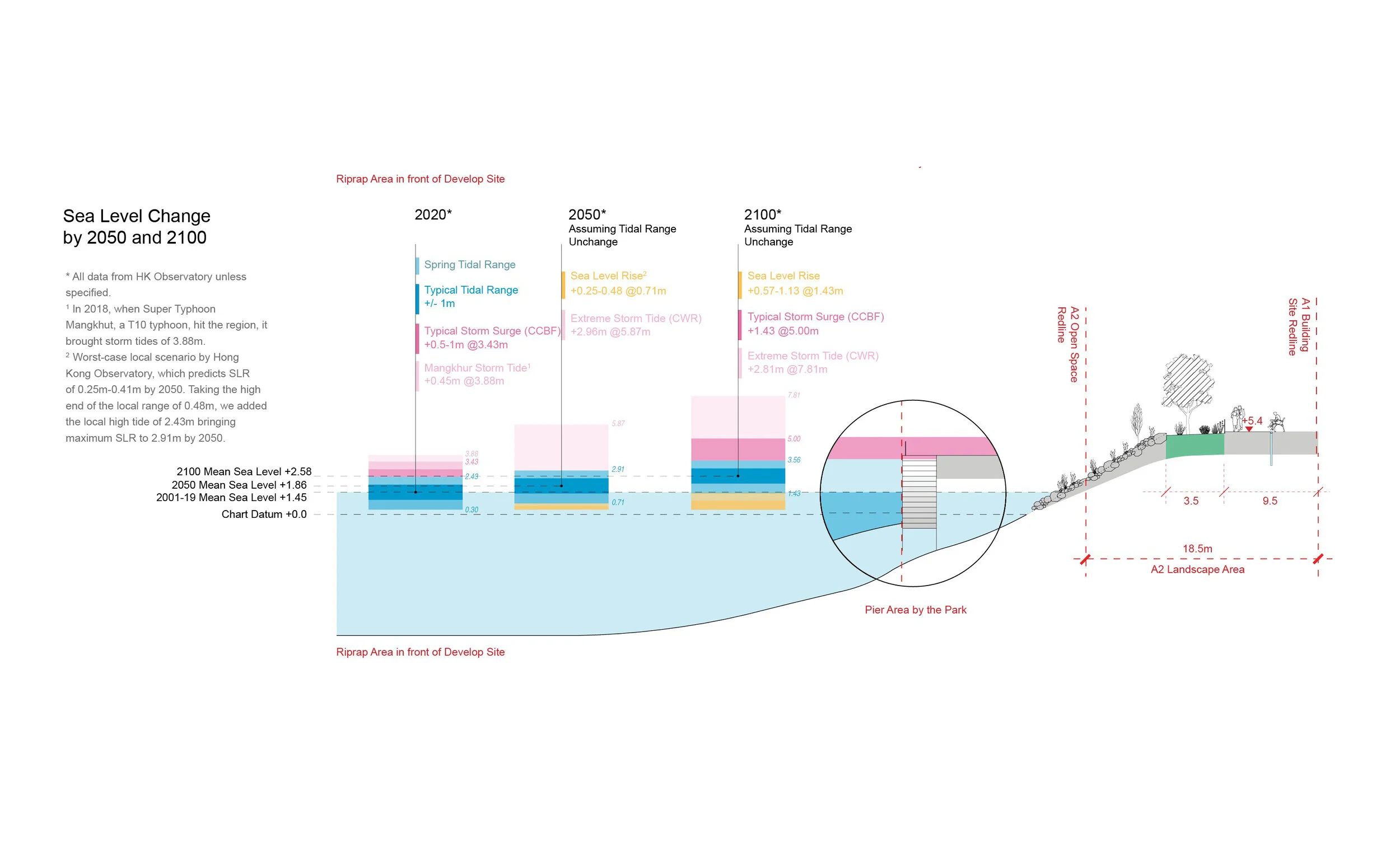
ECOLOGICAL EDGES AND COASTAL MITIGATION
- Development of a 'habitat enhanced shoreline' that fosters pedestrian access to water and uses managed, 'compartmentalized' flooding as an asset ecologically and economically.
- Enriching biodiversity along the coast and develop alternative water management methods that complement existing water management, areas of research include: flood management, rip-rap and living seawalls, 'transfer shade rights' strategies for offseting reclamation to other areas.
- Foundation and Structural strategies for raising the building above grade allowing public open space and coastal habitat to occupy the ground floor
- Facade and Massing strategies that maximize porosity and the integration of living horticulture and landscape
TYPE
Feasibility Study, Urban Planning
Size
5.5 ha
LOCATION
Hong Kong
YEAR
2020
Client
Hong Kong Cyberport Management Company Limited
Collaborators
The University of Hong Kong
Pratt Institute
Status
On-going